Neighborhoods
The administrative territory of the city is divided into 25 neighborhoods within the following boundaries.
1. The Centre – is located on the site of the historical town centre, encompassing all of the territory between the Daugava river, 18th Novembra street, Stacijas street, Maizes street, Sakņu street, Parādes street and Rīgas street.
2. Esplanāde – the territory between the Daugava river, Rīgas street (including Dubrovin’s Park), Parādes, Sakņu, Maizes, Stacijas and Kārklu street (up to railway track);
3. The Fortress – the territory between the Daugava river, Vaļņu street, Motoru street, Ceriņu and Silu street;
4. Vizbuļi – the territory between Ceriņu street, Silu street, Motoru street and Rīga highway;
5. Dzintari – the territory between the Daugava and the border of the building site along Daugavas street;
6. Mežciems – the territory between the north-eastern border of the city, the Daugava river, Vizbuļu street and Riga highway;
7. Viduspoguļanka – the territory to the north from the lake Šūņu up to the northern border of the city, Vidzemes street, the Čornaja river and the land property at 20 Cēsu street;
8. Jaunā Forštadte – the territory between the northern border of the city (Rēzeknes street), Piekrastes, Arendoles, Zeltkalna and Baložu street;
9. Vecā Forštadte – the territory on the banks of the lake Šūņu between the border of the city, the Čornaja river and transport hub of Vidzemes and Piekrastes streets;
10. Ezermala – the territory on the south-eastern bank of the lake Šūņu between the land property at 20 Cēsu street, railway and transport hub of Vidzemes and Piekrastes streets;
11. Dzelzceļnieks – the territory between the railway lines along Stacijas street and Varšavas street;
12. Ķīmija – the territory between Višķu street, the area of the railway yard and Stropi forest.
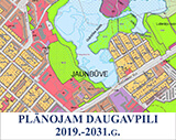
13. Jaunbūve – the territory between Višķu, Šaurā, and Aizpilsētas street, the lake Gubiščes, catholic cemetery, orthodox cemetery and railway;
14. Gajoks – the territory between the Daugava river, 18th November street, railway, Nometņu street and the river Meļņička;
15. Ruģeļi – the territory between the river Meļņička, the Daugava river, the eastern border of the city and Dunduru forest park;
16. Čerepova – the territory between Nometņu street, railway, including industrial building site at Dunduru street;
17. Grīva – the territory on the left bank of the Daugava river between the Daugava, Gulbju, Blaumaņa street, the planned extension of Laimas street (conditional line from the crossing of Laimas and Brjanskas street to the connection with Niderkūnes street), and Niderkūnes street;
18. Niderkūni - the territory on the left bank of the Daugava river between Gulbju, Blaumaņa, and M.Dambja street and the south-western border of the city;
19. Kalkūni – a separate territory of the city on the left bank of the Daugava river, separated from the city by the territory of Daugavpils district Kalkūni parish;
20. Liginišķi – the territory between the south-eastern border of the city, extension of Laimas street and Grīva cemetery;
21. Judovka - the territory on the left bank of the Daugava river between the Daugava, the eastern border of the city and Silenes street;
22. Jaunie Stropi – the territory between the 18th Novembra street, Lielais Stropu lake, Kokneses street and Stropi forest;
23. Mazie Stropi – the territory of summer cottages and private houses between Kokneses street in the south and railway track in the north;
24. Vecstropi – the territory between the eastern border of the city, Lielais Stropu lake, the territory of the central hospital of the city, 18th Novembra street and orthodox cemetery;
25. Križi – the north eastern territory of the city, which is bounded by the border of the city, railway and the territory of meat processing plant (including).


.jpg)